Mapping tree diversity in the Mabi Yaya Natural Reserve in Côte d'Ivoire
As part of the PRM 2 project around the Mabi Yaya National Reserve, an internship on mapping woody biodiversity has just been successfully completed by Ambroise Yeboua.
>> Complete internship report to download at the bottom of the page or here
>> Summary presentation of the internship report to download at the bottom of the page or here
Approach
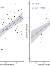
Using Sentinel 2 images (10 m resolution) and an package developed in R (biodivMapR package developed by Féret and de Boissieu, 2020), two tree diversity maps were produced: α diversity (Shannon index = local species diversity) and β diversity (Bray-Curtis dissimilarity = species communities difference between site). These maps are based on from the analysis of the variability of the spectral information in the images. This methodology, applied to medium-resolution images, has so far been little validated in the field.
At the same time, a major floristic inventory effort has been carried out in the reserve. The abundance of woody species was collected in 44 plots of 1256 m² each. The diversity indicators α (Shannon index) and β (Bray-Curtis dissimilarity) were calculated from the data measured in the field and then compared with those calculated from satellite images (estimated data).
Results
The results obtained show that there is a significant relationship between the data measured in the field and those estimated by biodivMapR for α-diversity data with an R² = 46.11% (Shannon index). For β-diversity, the correspondence between measured (field) and estimated (biodivMapR) data was evaluated at 44.34%. Our results indicate that the biodivMapR method using Sentinel-2 images can predict a relatively high percentage of variance in species richness and potentially provide a framework for mapping and predicting α and β diversity of tropical forest trees. Nevertheless, in order to enable its use in both operational and scientific contexts such as decision support, further studies targeting different ecosystems need to be conducted.
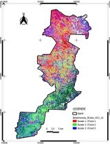
Based on statistical analysis of the β-biodiversity map and field observations from inventories, 4 classes of plant communities were defined: old-growth dense forest, degraded forest, regenerating forest and secondary-type forest. It turns out that these classes represent different levels of degradation or human disturbance. These maps therefore make it possible to spatialise the different types of forest throughout the Reserve and can be used by the protected area manager to target patrols and field observations.
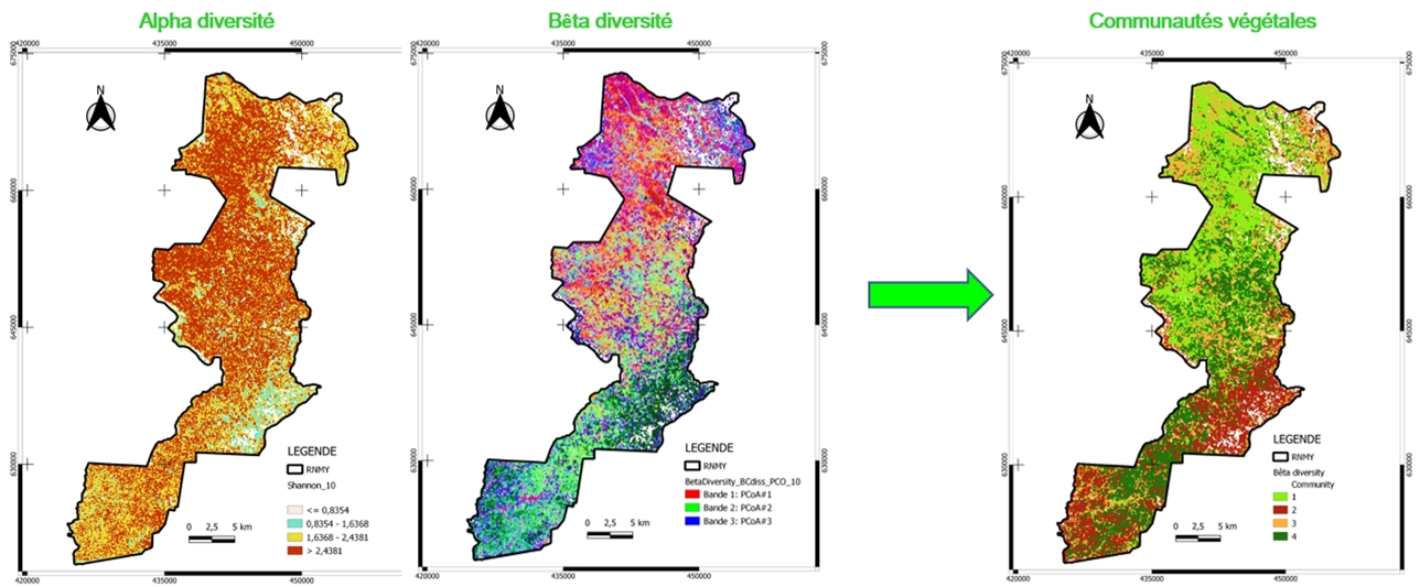
Map of plant diversity of the Mabi Yaya reserve: maps from the biodivMapR package, validated and interpreted in 4 classes using field inventories
Reference : Féret J.-B. et de Boissieu F. 2020. biodivMapR: An r package for α- and β-diversity mapping using remotely sensed images. Methods in Ecology and Evolution, 11(1), p. 64 70. DOI : 10.1111/2041-210X.13310
This mapping was carried out as part of the PRM2 project (see here), co-financed by the French Fund for the Global Environment (FFEM) and the Delegation of the European Union to the Republic of Côte d'Ivoire.
Related projects
TERRESIL - Territorial approach as a lever for socio-environmental resilience in 3 African landscapes of priority interest for biodiversity
See more
PRM2 - Preserve the biodiversity of Mabi-Yaya & Strengthen the socio-economic development of the Mé
See moreRelated documents
Presentation - Mapping of plant biodiversity in the Mabi-Yaya Nature Reserve in Côte d’Ivoire