News - Mar 21, 2019
Our drone tests in Ivory Coast and Madagascar to identify their capabilities
Can the drone be used to reduce the cost of analyzing satellite images? Or to get new information for new services?
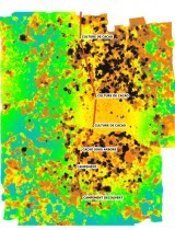
This is a test report that our team has made to test the capabilities of drones to provide useful information on monitoring and evaluation of land and forests. The document describes hardware, software, battery capacity/ha, methods, costs, image processing, working time, image analysis and potential applications.
Examples (not exhaustive ... to dig):
- Counting trees (survival rate, size, state of health, canopy surface, tree height)
- Tracking cleared parcels
- Basemap generation for Municipal Development Schemes
- Monitoring rubber plantations, coffee, cocoa, improvement of plantation management boards
Report below.