Thesis defense on the dynamics of deforestation and forest degradation in Côte d'Ivoire
Tiodionwa Ouattara received the title of Doctorate in Science and Technology, Mention: Remote Sensing and GIS, Specialty: Planning, Land and Ecosystem Management. His work focuses on "Land and Deforestation Monitoring by Spatial and Aerial Remote Sensing in the East and South-East of Côte d'Ivoire".
Context and objectives
The Ivorian State initiated a new forest policy in 2019 which aims to curb deforestation. To support this deforestation reduction policy and better understand the current dynamics, fine and regular mapping of changes in land occupation and use is necessary. However, strong limitations affect these monitoring systems: high cloudiness, spatial resolution, frequency of acquisition as well as complexity of agrosystems, etc. which explains their low operational use in Côte d'Ivoire despite their potential. Moreover, such studies of land cover mapping by satellite must take into account the rapidity of the underlying anthropogenic processes, it is necessary to develop reproducible approaches on the annual or intra-annual time scale according to the process.
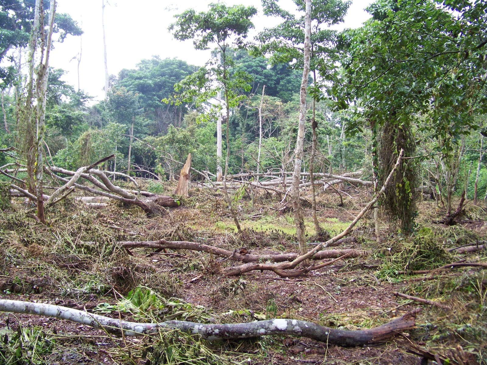
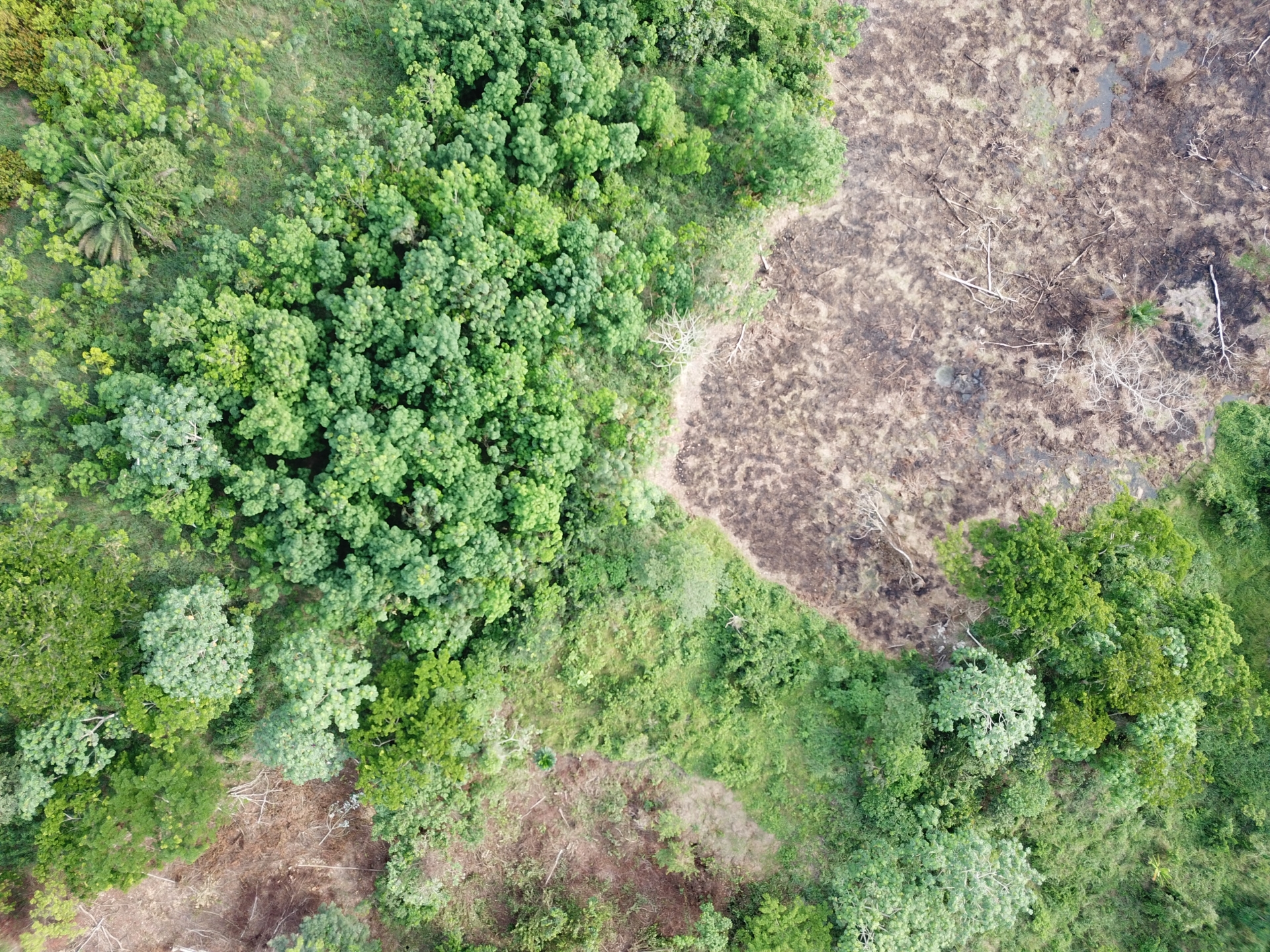
Deforestation in the classified forest of Bossématié for the establishment of cocoa farming
This is the issue addressed in this study, which seeks to test and develop methodologies combining the analysis of data from space and aerial remote sensing (Drone) and field data to assess and better understand changes in use land in Côte d'Ivoire. This work was carried out within the framework of the Mé REDD+ project and focused in particular on the dynamics of deforestation and forest degradation at the regional and local scales.
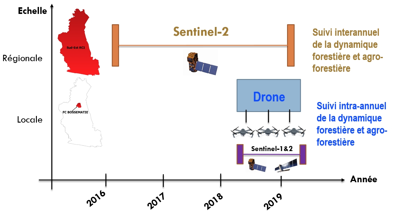
Methodological approach to research work: regional scale (East and South-East of Côte d'Ivoire) and local scale (Classified Forest of Bossématié)
Results
The results show that the extension of cash crops (cocoa-coffee, rubber and oil palm), undifferentiated crops and fallow land as well as infrastructure (housing and roads), led to a deforestation rate of 4.95 % per year in the East and South-East of Côte d'Ivoire between 2016 and 2019.
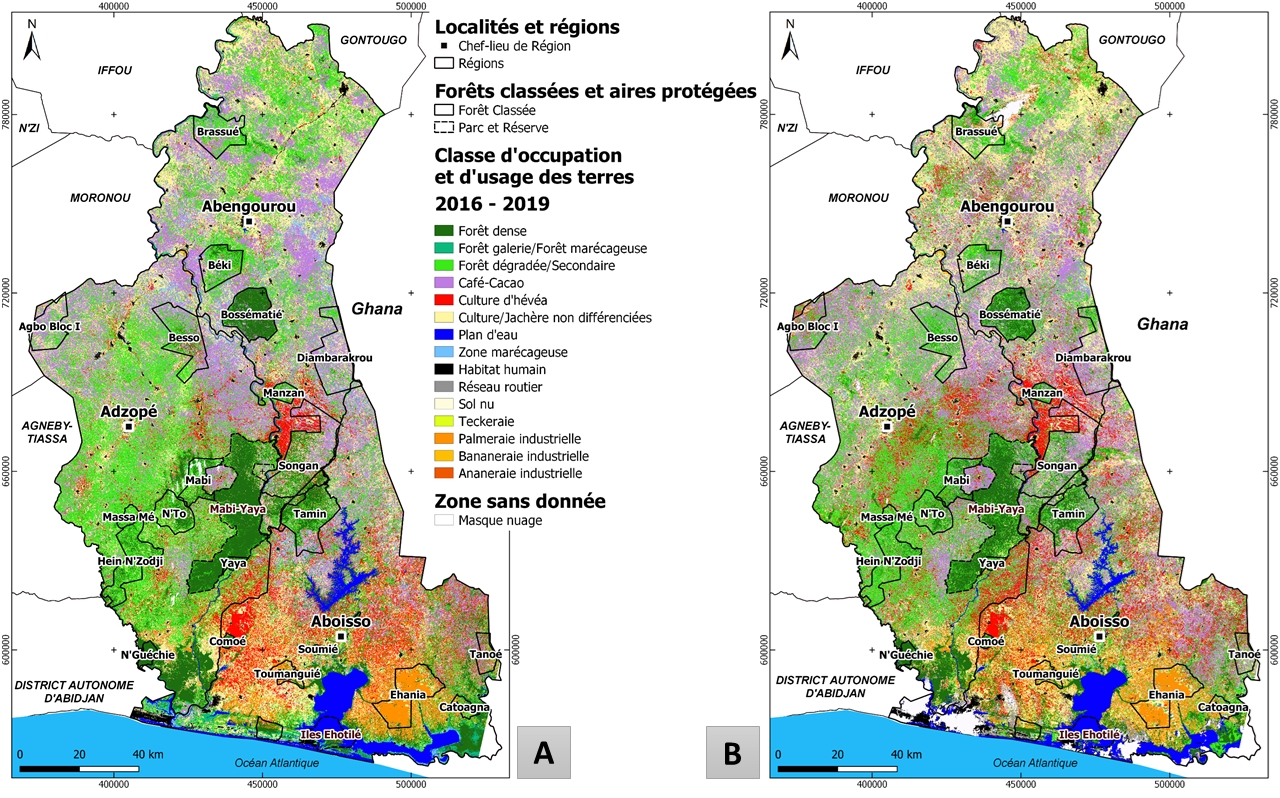
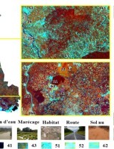
Maps of land occupation and use in the East and South-East of Côte d'Ivoire in: A/ 2016 and B/ 2019
Dense forest formations are converted first to degraded or secondary forests, then to crops or undifferentiated fallows before cocoa-coffee crops appear. In the case of degraded or secondary forests, it is cocoa-coffee crops that remain the first cause of deforestation, then undifferentiated crops or fallows before the appearance of rubber.
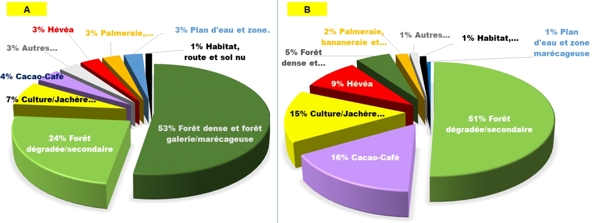
Distribution diagram showing post-deforestation land uses between 2016 and 2019 in the south-east of Côte d'Ivoire concerning A/ dense forest formations and B/ degraded or secondary forests
Analyzes at the local level have shown a significant loss of biodiversity in the classified forest of Bossématié and also the importance of the drone in the evaluation of the dynamics of deforestation and forest degradation in forest environments. These results shed new light and quantify post-clearing land uses, in particular the impact of cash crops. They also underline the importance of secondary formations in the landscape (former abandoned cocoa plantations) and their recent conversions to other crops, particularly rubber.
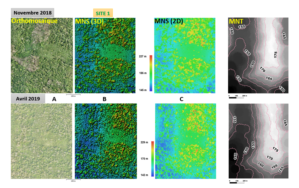
Illustration of Orthomosaics (A), Digital Surface Models in 3D (B), 2D (C) and Digital Terrain Models (D) between 2018 and 2019 on a site in the Bossématié classified forest
Conclusions and outlooks
This work on a regional scale has made it possible both to quantify the extent of the changes as well as the probable causes of these changes, making it possible to better understand the ongoing changes in the territory. The methodology is easily reproducible in other regions or as part of an update (open source tool and free data).
In addition, ongoing reflections on technical choices, in the context of spatial land monitoring (SST) at the national level, could benefit from the lessons learned from this study. In particular, the results of this work demonstrate that it is possible to detect deforestation and forest degradation with the drone. This would make it possible to significantly refine the Forest Reference Emission Level (NERF) transmitted by Côte d'Ivoire to the United Nations Framework Convention on Climate Change (UNFCCC) as well as the establishment of a monitoring system. early warning to guide actions in the field.