BLUEMANG - Mangrove deforestation analysis in North-West Madagascar
Partners
Main goals
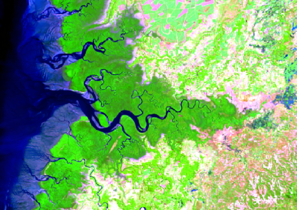
The bays of Ampasindava, Tsimipaika and Ambaro in northwest Madagascar contain the country’s largest mangrove ecosystem, which is also currently experiencing the most dramatic deforestation nationwide. Blue Ventures is partnering with local stakeholders to lower deforestation and certify a mangrove carbon project in Tsimipaika Bay under the VCS standard. A key part of the project development is to establish a ‘without‐project’ deforestation scenario. Nitidæ is in charge of this specific task.
Specific objectives
Establishing a ‘without‐project’ deforestation scenario, following scientifically robust methods that comply with the requirements of the VCS standard.
Beneficiaries
Blue Ventures Conservation
Results
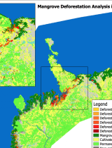
Submission to Blue Ventures of the reports explaining the methodologies & R scripts used and maps produced.
Activities
A1. Remote sensing analysis of historical deforestation of mangroves from 2000‐2014.
A2. Development of a model for deforestation rate from population density for 2015‐2050.
A3. Development of a model for the location of future deforestation using spatial explicative factors for the period 2015‐2050.
Related people
Frédérique Montfort
Doctor of AgroParisTech in environmental sciences, she brings her expertise on the biodiversity component and on the degradation and restoration of forest landscapes. She joined N’Lab de Nitidæ in 2017 to carry out her thesis with the association, UR Forêts & Sociétés and UMR Tétis on the degradation and restoration of Miombo forest landscapes in Mozambique. She is currently conducting studies and technical support (capacity building, technology transfer) on various projects of the association
See more
Clovis Grinand
PhD in Functional Ecology and Agronomic Sciences (SupAgro, IRD and CIRAD) and specialized in Localized Information Systems for Spatial Planning (AgroParisTech), he is an expert in land use change monitoring using remote sensing, digital soil mapping and spatial modeling applied to forestry, agronomy and landscape ecology. He is the author of numerous international scientific publications.
See more
Marie Nourtier
PhD in Forest sciences conducted at INRA Avignon, EMMAH research lab, she brings her expertise in forest ecology, support for REDD+ mechanism and carbon accounting, Environmental and social impact assessment of projects, project management and supervision of technical work
See more