LUPS - Development of a spatial module for the Land-Use Planner tool
Partners
Main goals
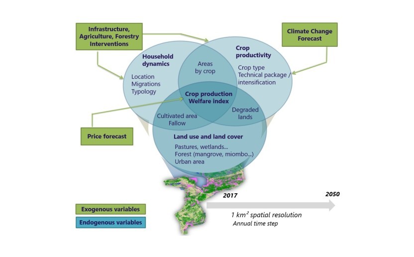
EFI develops the Land-use Planner (the LUP), a tool for socio-economic modeling and land use change scenarios analysis, to improve territorial planning, help resolve conflicting situations over land allocation, plan investments towards more sustainable agriculture for EFI's partners, governments, decentralized administrations and civil society.
LUP is an online operational tool used since 2021 in different countries and offers a multitude of socio-economic and environmental indicators. However, there is no spatial dimension representing the simulated land use conversion dynamics allowing full awareness of future landscape changes and enlightening decisions. The objective of this work is to propose a prototype of space module to the LUP and in preparation for the integration of automatable space functionalities directly into the platform.
Specific objectives
SO1. Develop a processing chain aimed at spatially modeling the dynamics of land use change, in particular deforestation and reforestation, based on the simulation results of the Land-use Planner simulation tool and spatial data.
This work will be based on the work of Nitidæ Lab' (Grinand et al, 2020) and applied in the Mé REDD+ project.
SO2. Operationalize the processing chain through the development of an interactive and dynamic online tool prototype allowing users to operate the processing chain and visualize its results. Regional data, spatial modeling tools and the development of open source dashboards will be mobilized in order to offer a generic and reproducible tool.
Related people

Clovis Grinand
PhD in Functional Ecology and Agronomic Sciences (SupAgro, IRD and CIRAD) and specialized in Localized Information Systems for Spatial Planning (AgroParisTech), he is an expert in land use change monitoring using remote sensing, digital soil mapping and spatial modeling applied to forestry, agronomy and landscape ecology. He is the author of numerous international scientific publications.
See more
Etienne Duperron
Graduated of an agricultural engineering school (INP-ENSAT), he specialized in spatial information processing via the Master 2 in Geomatics Sciences in Environment and Planning (SIGMA) from the University of Toulouse Jean Jaurès. After working for two years on forest degradation and reforestation in the Brazilian Amazon, he joined the team to provide support on processing, analysis and spatial modeling related to the development and sustainability of territories, mainly in Mozambique
See moreLUCCIA - Co-development of a simulation…