LUCCIA - Co-development of a simulation and decision support tool for land use planning and impact assessment in the context of climate change

Partners
Main goals
Provide technical assistance to the FNDS (Fundo Nacional de Desenvolvimento Sustentavel) and in particular to the MRV (Monitoring-Reporting-Verification) unit in its monitoring-evaluation missions by developing a spatialized decision support tool in order to simulate and Assess the impact of national development scenarios and project interventions in the agriculture and forestry sector.
Specific objectives
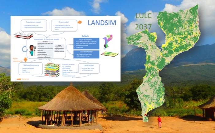
SO1. From the LANDSIM prototype platform, develop an operational spatio-temporal simulation tool for the assessment of the future impact of land development scenarios and project interventions in the agriculture and forest sector
SO2. Apply and test the simulation tool in a national case study on climate change mitigation and/or adaptation scenarios and a regional case study on ex-ante impact assessment conservation and development project
SO3. Develop national capacities to: i) operationally apply the simulation tool for different interventions on the territory, ii) provide dashboards of indicators based on simulation results, and iii) understand and modify the internal processes of the simulation tool for future platform improvements
Beneficiaries
MRV (Monitoring-Reporting-Verification) Unit of the Fundo Nacional de Desenvolvimento Sustentavel (FNDS)
Results
R1. Kick-off meeting including stakeholder mapping
R2. Progress report after nine months of project and presentations to the committee
R3. Progress report after 16 months of project and presentations to the committee
R4. Final report and presentations: delivery of the tool, source code, user manual and training documents
Activities
A1. Conducting workshops to assess the needs of future users and review the main land cover change modeling tools in order to determine the improvements to be made to the existing version of the tool simulation prototype
A2. Development and operationalization of the simulation tool through (i) the construction of its central source code from the prototype, (ii) the development of new modules, and (iii) the design of tables of edge for offline/online display of outputs
A3. Realization of regional and national case studies then reinforcement of the capacities of the stakeholders, in particular on the construction, the execution and the analysis of the results of scenarios
A4. Coordination, governance and communication
Related people
Clovis Grinand
PhD in Functional Ecology and Agronomic Sciences (SupAgro, IRD and CIRAD) and specialized in Localized Information Systems for Spatial Planning (AgroParisTech), he is an expert in land use change monitoring using remote sensing, digital soil mapping and spatial modeling applied to forestry, agronomy and landscape ecology. He is the author of numerous international scientific publications.
See more
Etienne Duperron
Graduated of an agricultural engineering school (INP-ENSAT), he specialized in spatial information processing via the Master 2 in Geomatics Sciences in Environment and Planning (SIGMA) from the University of Toulouse Jean Jaurès. After working for two years on forest degradation and reforestation in the Brazilian Amazon, he joined the team to provide support on processing, analysis and spatial modeling related to the development and sustainability of territories, mainly in Mozambique
See more
Jean-Baptiste Roelens
Holder of a master Tropical environment and Biodiversity, he worked for 3 years in French Guyana, notably as forest ecology and soil science research officer at CIRAD. From 2008 to 2016 he worked at the WWF in Madagascar, France and Democratic Republic of Congo as Forest and Climate program manager. At WWF, he supported conservation, forest landscape restoration and REDD+ projects, he also conducted campaign and advocacy work on forest policies and energy infrastructure development. He joined Etc Terra - then nitidæ - in May 2016 as MOZBIO project manager around the Gilé national reserve in the Zambézia province in Mozambique.
See more
Matthieu Tiberghien
Holder of a Master's degree in Management from the Paris-Dauphine University and a Master in "Social Policies and Planning in developing Countries" from the London School of Economics, he brings his expertise in project building and project management in renewable energy, REDD+, technical engineering, economic and financial due diligence, business development, strategic partnerships, fundraising and human ressources management
See more
Frédérique Montfort
Doctor of AgroParisTech in environmental sciences, she brings her expertise on the biodiversity component and on the degradation and restoration of forest landscapes. She joined N’Lab de Nitidæ in 2017 to carry out her thesis with the association, UR Forêts & Sociétés and UMR Tétis on the degradation and restoration of Miombo forest landscapes in Mozambique. She is currently conducting studies and technical support (capacity building, technology transfer) on various projects of the association
See more
Manuel Uiliamo
Holder of a master's degree in Control and Automation Engineering from the University of Sidi Bell Abbes - Algeria with strong skills in global IT. His training allowed him to acquire an excellent knowledge of a variety of programming languages and the basics of industrial electricity. He is also a motivational content creator with basic knowledge in audiovisual editing. On the LUCCIA project in Mozambique he was able to provide his expertise in computer programming and spatial analysis. Since January 2024, he has been working on the ACAMOZ 2 project as GIS and IT Development manager.

Palmira Marinho Gravata Vitória
Graduated in economics and education from the Pedagogical University of Mozambique, with 7 years of experience as an administrative assistant, since 2019 she has been responsible for administration, finance, human resources management and relations public.
LAUREL - Land Use Planning for Enhanced…