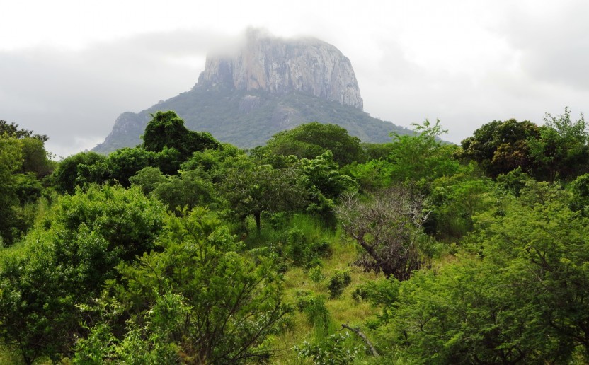
LAUREL - Land Use Planning for Enhanced Resilience of Landscapes in Mozambique
Partners
Main goals
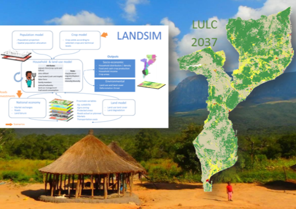
The Land Use Planning for Enhanced Resilience of Landscapes (LAUREL) program led by the World Bank aims to support integrated decision making for landscape management in Mozambique, through improved spatial data on land degradation, and through the development of prototype platform (LANDSIM) for simulating, evaluating, and re-orienting as appropriate, land use and land use change processes
Specific objectives
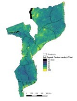
O1. To develop a sound, consistent, up-to-date and evidence-based baseline of land degradation in Mozambique
O2. To develop a national-scale spatially explicit land use change simulation prototype for evaluating the impact of Mozambique policy and interventions incentives
Beneficiaries
Governement of Mozambique
Results
R1. A nationaly consistent database of land degradation maps and sound information of the underlying causes of the degradation indicators observed in Mozambique
R2. A spatial-explicit land use change simulation prototype that enable to estimate the impacts of government policy or interventions on household welfare as well as agricultural production and environmental impacts
Activities
A1. Developpment of the Land Degradation Baseline. For this objective we are following the latest guidance of international UN conventions and base our development on state-of-art earth observation technology (e.g. remote sensing times series analysis, Google Earth Engine)
A2. Development of the Land use change simulation Prototype (LandSIM). For this objective we are following several key steps: i) estimate population and population density; ii) describe household architecture, production practices and natural resource use, iii) link the households to the economy and markets, iv) incorporate climate change effects, v) design future scenarios, run the model and link to policy. Thoses modules are developped using an open-source modeling platform
Related documents
LAUREL An Analysis of Land Use Changes and Land Degradation in Mozambique
LAUREL Land Simulation Approach Paper
LAUREL Land Degradation Approach paper
LAUREL Land Simulation Progress Report
LAUREL Land Degradation Progress Report
Related people
Clovis Grinand
PhD in Functional Ecology and Agronomic Sciences (SupAgro, IRD and CIRAD) and specialized in Localized Information Systems for Spatial Planning (AgroParisTech), he is an expert in land use change monitoring using remote sensing, digital soil mapping and spatial modeling applied to forestry, agronomy and landscape ecology. He is the author of numerous international scientific publications.
See more
Frédérique Montfort
Doctor of AgroParisTech in environmental sciences, she brings her expertise on the biodiversity component and on the degradation and restoration of forest landscapes. She joined N’Lab de Nitidæ in 2017 to carry out her thesis with the association, UR Forêts & Sociétés and UMR Tétis on the degradation and restoration of Miombo forest landscapes in Mozambique. She is currently conducting studies and technical support (capacity building, technology transfer) on various projects of the association
See more
Jean-Baptiste Roelens
Holder of a master Tropical environment and Biodiversity, he worked for 3 years in French Guyana, notably as forest ecology and soil science research officer at CIRAD. From 2008 to 2016 he worked at the WWF in Madagascar, France and Democratic Republic of Congo as Forest and Climate program manager. At WWF, he supported conservation, forest landscape restoration and REDD+ projects, he also conducted campaign and advocacy work on forest policies and energy infrastructure development. He joined Etc Terra - then nitidæ - in May 2016 as MOZBIO project manager around the Gilé national reserve in the Zambézia province in Mozambique.
See more
Matthieu Tiberghien
Holder of a Master's degree in Management from the Paris-Dauphine University and a Master in "Social Policies and Planning in developing Countries" from the London School of Economics, he brings his expertise in project building and project management in renewable energy, REDD+, technical engineering, economic and financial due diligence, business development, strategic partnerships, fundraising and human ressources management
See moreMOZBIO - Support to the development of…