A pilot study of remote sensing by drone and satellite to strengthen the cashew sector in Mozambique
Supporting and strengthening the cashew sector in Mozambique
From the producer's plot to the cashew nut buyers, passing through the processing factories, Nitidæ's activities are diverse. Today our partner, the Almond Institute of Mozambique (IAM, IP), a national institute for the development of the sector is also responsible for the selection and distribution of cashew plants and the fight against diseases and pests in all cashew producing provinces of Mozambique. Accurately assessing in-country production remains a significant challenge for IAM, IP and value chain actors. Each year, there are increasing disparities between the estimated national production and the production confirmed by the statistics of the cashew nut sub-sector (quantities processed, exported, etc.). It is clear that the informal domestic consumption or illegal export of cashew nuts to, among others, Tanzania can constitute a significant part of this production which, in fact, is difficult to estimate.
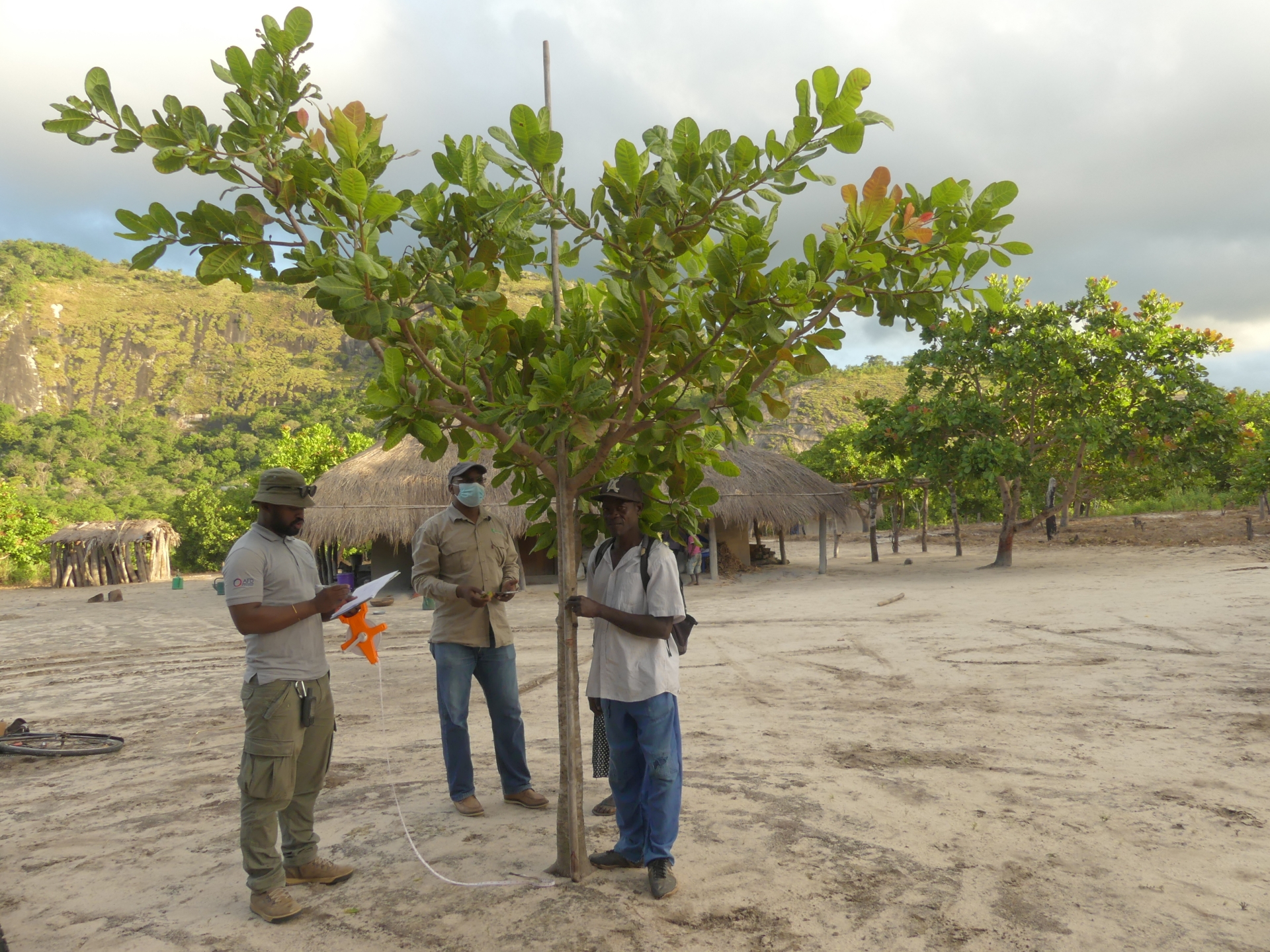
Illustration of measures of cashew tree characteristics
In this context, the Cashew Value Chain Support project in Mozambique (ACAMOZ) conducted a pilot test in the districts of Gilé and Pebane, in the province of Zambézia, in order to develop a methodology for identifying the number of cashew trees at the using remote sensing techniques (drone and satellite images) and determine the cashew nut production potential on a regional scale.
Main results of the pilot study
In this context, two data collection and training missions on the acquisition of images by drone for technicians and engineers from IAM, IP and Nitidæ took place in 2021 in the districts of Gilé and Pebane, around the Park. National of Gilé (PNAG). These missions aimed to:
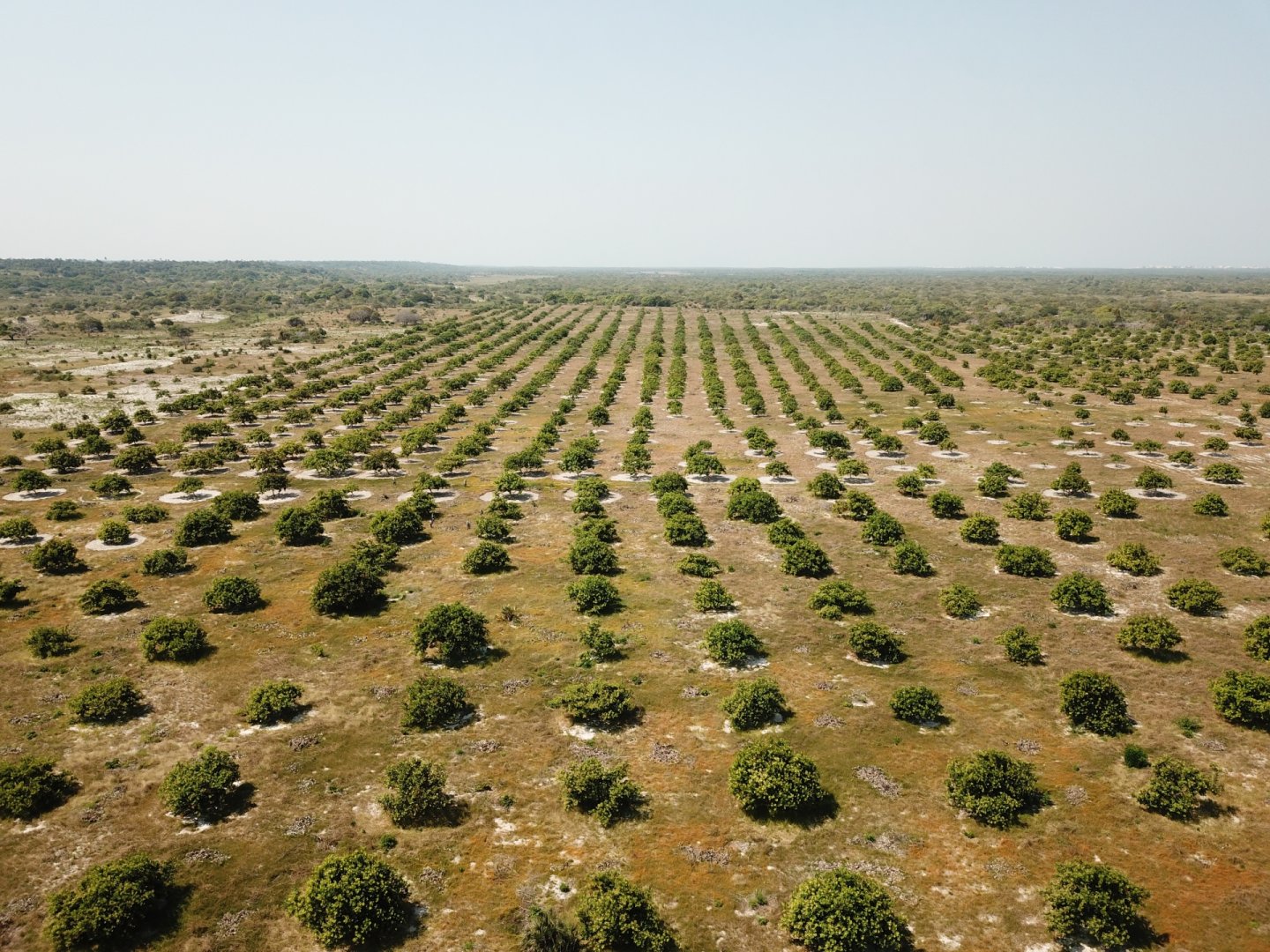
- Production of orthophoto and digital surface model. Drone flights were carried out at a height of 100 m over an area between 20 and 40 hectares in 10 villages (Figure 1)
- Surveys and field measurements. Dendrometric variables and production data on these same mapped surfaces were measured in cashew and mango trees.
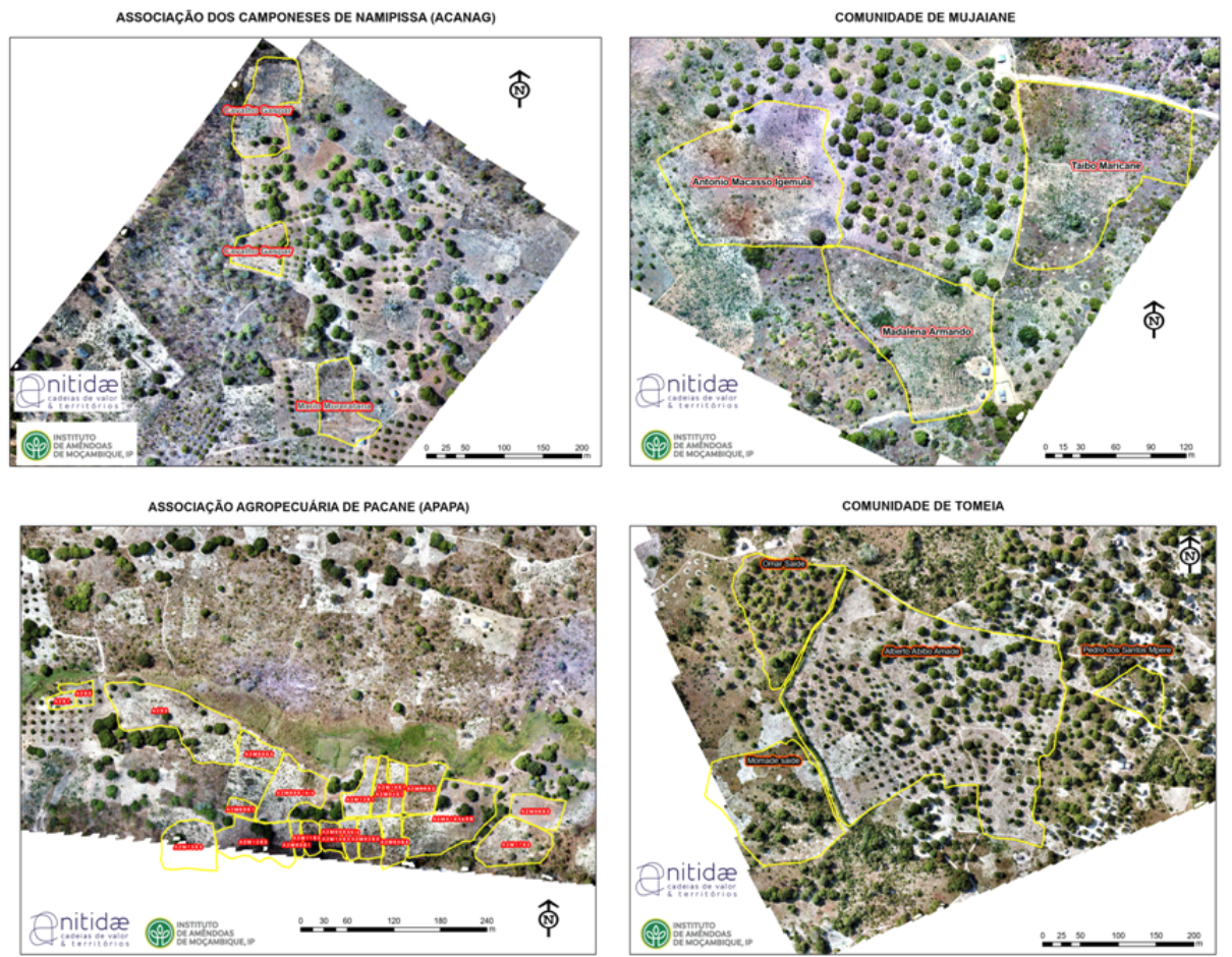
Figure 1: Illustration of drone image acquisitions, orthophoto production and delimitation of cashew orchards of village associations. The majority of the study sites show sparse and irregular traditional cashew plantation systems
Then, a third study phase dedicated to data analysis and processing ended in September 2022, where the Lab’ team was able to:
- Develop a methodology for the automatic detection of dendrometric variables from the digital canopy model production. These variables include tree top detection and crown delineation, and calculation of crown areas and perimeters as well as average tree height.
- Develop a model for the identification of cashew trees based on orthophotos crossed with the detection of trees with an accuracy of 87%.
- Demonstrate that the correlation between the dendrometric data measured in the field and those measured with the drone images was strong (r > 0.78) which led to the conclusion that we could use the data extracted from the images of drone to extrapolate the identification of cashew trees to all the orthophotos.
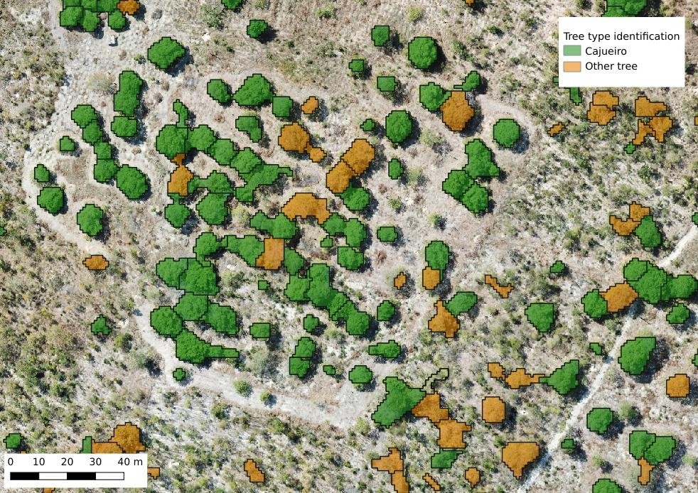
Figure 2: Final tree detection map to validate the automatic cashew tree detection system
With the data from the drone and field survey, it was therefore possible to adjust a production model using the crown circumference, the crown surface and the height of the cashew tree as independent variables (linear model). The same model was applied to estimate the average production per hectare and the total production potential, on all the trees of the 10 study sites (> 3000 cashew trees for 239 ha)
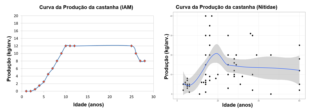
Figure 3: Production curve according to age. IAM production data (left) and production data estimated as part of this study (producers' declaration of average annual production)
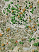
Finally, satellite images were also used in order to estimate the surfaces of cashew orchards on a larger scale. The mapping of the orchards using satellite images revealed that in Gilé there are more orchards than in Pébane and therefore a higher production potential. A district scale estimate: based on assumptions (e.g. 12 kg/tree on average according to IAM,IP data, see Figure 3) or field yield measurement shows potential production of 7484 and 5433 tons of cashew in 2021 in the districts of Gilé and Pebane respectively.
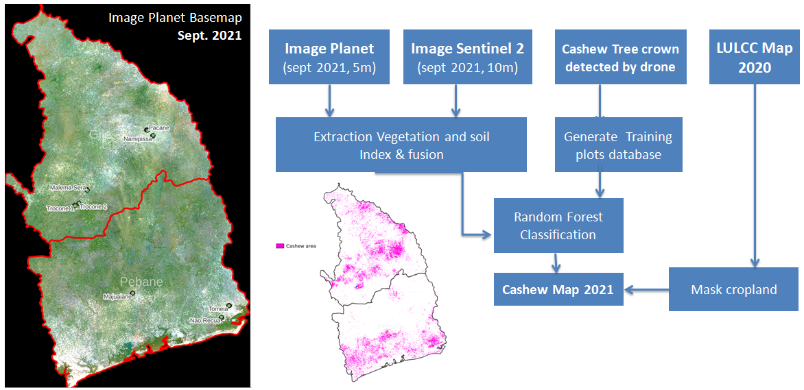
Figure 4: District-wide orchard mapping methodology (right). Left Image Planet September 2021 of the study area in Gilé and Pebane districts in the province of Zambézia
Conclusion
The methodology and results obtained from this pilot study are presented in our report below, along with our recommendations for improving the model and transferring the methodology to the staff of public institutions.
Related projects