Documents
Filters
Remote sensing
142
results
Communication
Agriculture, Agroforestry, Spatial Planning, Degradation-Restoration, Forest, Remote sensing
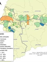
Support for the establishment of a Regional GIS unit for the Mahavotra Forestry, Agroforestry and Land Management Project
Project report
Agroecology, Biodiversity, Climate, Forest, Market, REDD+, Remote sensing
Namuli Initiative Progress Report January 2020 on creation of a new protected area in Mozambique
Technical document
Agriculture, Spatial Planning, Climate, Degradation-Restoration, Forest, Modeling, REDD+, Remote sensing
LAUREL An Analysis of Land Use Changes and Land Degradation in Mozambique
Technical document
Agriculture, Climate, Forest, Remote sensing
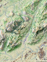
Land Use and Land Cover Map of Ribaue Mountains (Mount Ribaue and Mount M’paluwe)
Scientific publication
Climate, Degradation-Restoration, Forest, REDD+, Remote sensing
Sensitivity analysis of land productivity change calculation in Mozambique
Scientific publication
Agriculture, Spatial Planning, Climate, Degradation-Restoration, Forest, Modeling, Remote sensing
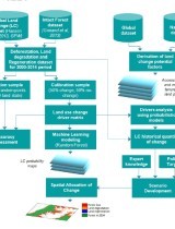
Landscape-scale spatial modelling of deforestation, land degradation, and regeneration using machine learning tools
Communication
Agriculture, Organic Agriculture, Spatial Planning, Bioenergy, Biodiversity, Climate, Degradation-Restoration, Forest, Market, REDD+, Remote sensing
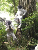
Nitidæ's approach and learnings for landscape projects in South-Eastern Côte d'Ivoire
Project report
Agroecology, Biodiversity, Climate, Forest, Market, REDD+, Remote sensing
Namuli Initiative Progress Report January 2020 on creation of a new protected area in Mozambique
Project report
Organic Agriculture, Agroforestry, Spatial Planning, Bioenergy, Biodiversity, Forest, Market, REDD+, Remote sensing
Third annual activity report of the Mé REDD+ Project (in french)
Technical document
Agriculture, Organic Agriculture, Agroecology, Agroforestry, Spatial Planning, Biodiversity, Climate, Degradation-Restoration, Forest, Remote sensing
Master's thesis - State of the ligneous community of two wooded Sudanian savannahs under their local human pressures
Technical document
Agriculture, Organic Agriculture, Agroecology, Agroforestry, Spatial Planning, Biodiversity, Climate, Degradation-Restoration, Forest, Remote sensing
Shea resources in forest areas: the Shea Parks, an example of valorization and management in Burkina-Faso
Technical document
Agroforestry, Spatial Planning, Degradation-Restoration, Forest, Remote sensing
Forest plantation diagnosis of the Mahavotra project
Technical document
Agriculture, Agroecology, Biodiversity, Climate, Degradation-Restoration, Forest, Modeling, Remote sensing
Miombo woodland regeneration dynamics after slash and burn agriculture in Mozambique
Annual reports
Agriculture, Organic Agriculture, Agroprocessing, Spatial Planning, Bioenergy, Biodiversity, Climate, Degradation-Restoration, Forest, IWRM, Market, Modeling, REDD+, Remote sensing, ICT
Annual Report 2018 Nitidæ

Technical document
Biodiversity, Forest, Modeling, REDD+, Remote sensing