Documents
Filters
Remote sensing
143
results
Annual reports
Agriculture, Organic Agriculture, Agroprocessing, Spatial Planning, Bioenergy, Biodiversity, Climate, Degradation-Restoration, Forest, IWRM, Market, Modeling, REDD+, Remote sensing, ICT
Annual report EtcTerra 2015

Annual reports
Agriculture, Organic Agriculture, Agroprocessing, Spatial Planning, Bioenergy, Biodiversity, Climate, Degradation-Restoration, Forest, IWRM, Market, Modeling, REDD+, Remote sensing, ICT
Annual report RONGEAD 2015
Technical document
Agriculture, Spatial Planning, Climate, Degradation-Restoration, Forest, IWRM, Remote sensing
Ex-ante estimation of the impact of the PAD-North project on the GHG and carbon balance using the EX-ACT tool (EX-Ante Carbon-balance Tool)…
Annual reports
Agriculture, Organic Agriculture, Agroprocessing, Spatial Planning, Bioenergy, Biodiversity, Climate, Degradation-Restoration, Forest, IWRM, Market, Modeling, REDD+, Remote sensing, ICT
Annual report RONGEAD 2014
Annual reports
Agriculture, Organic Agriculture, Agroprocessing, Spatial Planning, Bioenergy, Biodiversity, Climate, Degradation-Restoration, Forest, IWRM, Market, Modeling, REDD+, Remote sensing, ICT
Annual report Etc Terra 2014
Technical document
Spatial Planning, Degradation-Restoration, Forest, Remote sensing
Measurement protocol - Pre-assessment of carbon sequestration planted species biomass
Scientific publication
Spatial Planning, Forest, REDD+, Remote sensing
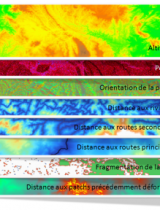
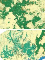
Estimating deforestation in tropical humid and dry forests in Madagascar from 2000 to 2010 using multi-date Landsat satellite images and th…

Annual reports
Agriculture, Organic Agriculture, Agroprocessing, Spatial Planning, Bioenergy, Biodiversity, Climate, Degradation-Restoration, Forest, IWRM, Market, Modeling, REDD+, Remote sensing, ICT
Annual report RONGEAD 2013
Annual reports
Agriculture, Organic Agriculture, Agroprocessing, Spatial Planning, Bioenergy, Biodiversity, Climate, Degradation-Restoration, Forest, IWRM, Market, Modeling, REDD+, Remote sensing, ICT
Annual report RONGEAD 2014
Annual reports
Agriculture, Organic Agriculture, Agroprocessing, Spatial Planning, Bioenergy, Biodiversity, Climate, Degradation-Restoration, Forest, IWRM, Market, Modeling, REDD+, Remote sensing, ICT
Annual report EtcTerra 2013
Scientific publication
Forest, REDD+, Remote sensing
Forecasting deforestation and carbon emissions in tropical developing countries facing demographic expansion: a case study in Madagascar -…
Scientific publication
Forest, REDD+, Remote sensing
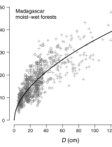
A universal approach to estimate biomass and carbon stock in tropical forests using generic allometric models - Ecological applications
Scientific publication
Forest, REDD+, Remote sensing
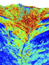
Human and environmental controls over aboveground carbon storage in Madagascar
Annual reports
Agriculture, Organic Agriculture, Agroprocessing, Spatial Planning, Bioenergy, Biodiversity, Climate, Degradation-Restoration, Forest, IWRM, Market, Modeling, REDD+, Remote sensing, ICT
Annual report RONGEAD 2012
Annual reports
Agriculture, Organic Agriculture, Agroprocessing, Spatial Planning, Bioenergy, Biodiversity, Climate, Degradation-Restoration, Forest, IWRM, Market, Modeling, REDD+, Remote sensing, ICT